

Navicup

Description of Navicup
Gamified audio tours and tourist maps for DMOs, interactive audio guides for museums, city tours and tour operators, white-label apps for theme parks, educational outdoor games and scavenger hunts for children, students, and local residents, orienteering competitions for sports enthusiasts, and app and web maps for large-scale events.
SELF-GUIDED AUDIO TOURS
Free and paid interactive audio-guided tours with games and digital companions. Available in up to 50 languages. Example: see our free country Grand Tours or paid city Walking Tours. Interactive audio-guide app platform for museums, city tours, tour operators, and Destination Management Organizations.
WHITE LABEL APPS FOR THEME PARKS
An interactive audio-guide app for outdoor and indoor use in zoos and other theme parks. Create immersive scavenger hunts and educational games to enhance visitors' experiences at your theme park. Show if objects are open or closed. Choose from our digital companions or create your own with the face and character of your mascot for social interaction with visitors. Build your own contactless bike (or other vehicle) rental system within your territory. Allow visitors to take and share photos with the theme park's design filters. Get statistics on where and when your visitors go and what they like to do.
OUTDOOR CLASSES FOR SCHOOLS
We help schools and teachers combine outdoor activities and learning. This gives teachers a break while allowing students to work independently. A school sports or theme day game/competition can be organized outdoors, combining physical activity with new knowledge acquisition. Create your events in minutes with the help of AI and reuse them as needed.
TRAVEL AND LARGE-SCALE OUTDOOR EVENT MAPS.
Simple, real-time information management with sub-event calendars and bookings. Available in up to 40 languages. Finds products, services, and friends, and simplifies navigation. Includes a photo gallery map and visit statistics. Gamify your events for added excitement! Object owners can submit their details, add pictures, and update information as needed. Event organizers approve applications, and Navicup automatically creates a digital public event map for websites and social media. Printable maps are also available, and the Navicup mobile app makes event navigation easier.
ORIENTEERING GAMES and COMPETITIONS.
Navicup suits many competition formats where competitors cross checkpoints, such as orienteering games and competitions. It can serve as a primary or secondary automatic time-keeping solution. With no special hardware needed, Navicup is ideal for recreational and professional sports events. Real-time performance (live locations, results) tracking adds excitement and allows competitors to adjust their strategy. Navicup enhances spectator engagement by enabling real-time progress tracking. Final results can be announced immediately, as referees receive checkpoint data in real-time or Navicup automatically detects crossings.
AUTOMATIC TIMEKEEPING FOR COMPETITIONS AND GAMES
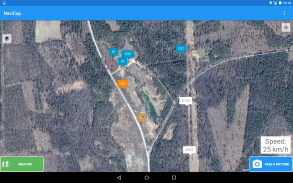
Navicup tracks checkpoints and routes in real-time. Verification methods include: Taking a photo with a app, automatically sent to referees. Automatic detection at checkpoints. Entering a numerical codes, passwords, or answering a question at checkpoints, and many other tasks.
POSITION AND TRACK
Navicup displays competitors` positions and trail on map. Application forwards information about competitors` position to Navicup home page, where spectators and support teams follow competitors` progress in real-time. Spectators and referees can also witness competitors` speed and possible violation of speed limits. It is also possible to replay competitors progress after the competition. GPS tracking is reliable even in case of unreliable mobile data connection.
Navicup is suitable for big sporting events as there is no longer necessary to rent tracking devices, everything is done in competitors own smartphone.


